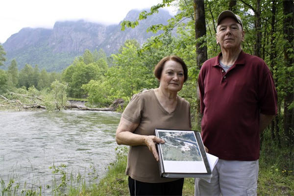
Jan Sullivan won’t go any closer to the crumbling edge of the Shake Mill Left Levee, but husband Robert “Sully” Sullivan is bolder. He takes a few steps closer to the void, where the grass of the earthen berm ends in a clean break, its base invisible under the overhang.
Jan’s caution is understandable. She and Sully have watched the levee that marks the northern edge of their home and business property disappear, faster and faster, over the last four years. The thought of the speedy devouring of their property keeps them up at night.
Worry “hits us like a ton of bricks,” Sully says.
“We don’t know what’ll happen if it keeps up,” adds Jan.
The lost levee
The Shake Mill Left Levee, also known as the North Fork Bridge Levee, was built in the early 1960s to protect the bridge and nearby 428th Avenue from erosion.
Gloria McNeely, a local historian and retired employee of the King County flood division, recalled how the levee system in North Bend originated. Voters approved a $5 million bond in 1960 following a big 1959 flood on the Snoqualmie River that killed a driver on Interstate 90. That money paid for levees.
“They were built with the participation of the riparian property owners,” McNeely said.
“Whenever (the county) saw a stretch of the river that would benefit from being rip-rapped, those owners were approached,” McNeely added.
Walking the remains of the levee along his property, Sully stopped every few feet to collect windblown sticks and branches, then toss them out of the way. He keeps the grass mowed up to his property line, which extends into a nearby oxbow lake.
“We’ve always maintained it,” said Sully. “When you’ve owned a piece of property for 45 years, that’s a long time.”
The Sullivans bought the site for a home and shake mill business in 1966.
“It was beautiful,” Sully said. “Here’s a picture of the mill.” He held up an aerial photo of the place, pointing to the loop road that wound around the north edge and is now eroded away.
“This is all gone,” he said. “It’s our bloodlife, from when we started the first little shake mill, and grew it.”
Walking the levee up to the oxbow, Sully points out how the earthwork is unchanged near the calm water.
“Most of this has good armament,” he said, referring to the stabilizing rocks, or rip-rap, encasing the bank.
“They didn’t armor it from the silo burner on down.” That’s why the bank went so fast, he says.
Erosion started slowly; the Sullivans noticed it about four years ago.
“The last two years, it’s just quadrupled,” Sully said.
The motion of the river removed tons of material from their side of the bank, piling a lot of it as rocky, gravelly deposits along the opposite shore and sending the rest downriver.
“A lot of our fill is over there,” he said. “What denotes our north boundary was the south shore of the river,” Sullivan said. In places, that boundary is now as far as 50 feet out in the water.
The Sullivans have spent about four years seeking county action on the levee, which has now been destroyed up to within about 300 feet of the North Fork Bridge,
A few years ago, “it wouldn’t have taken a lot of armament to stop this erosion,” Sully said. “Look at it now.”
Changing channel
Pushing for action from King County, the Sullivans have become increasingly frustrated with the response. At one point told that their levee was on the roster for repairs, the Sullivans instead became a candidate for buy-out.
With the scale of the damage and the natural processes now changing the North Fork, the county has ruled out a levee replacement. County officials say the situation does not warrant emergency action.
“We’ve concluded that the best approach is to make the Sullivans a fair market value offer for their property,” said Clint Loper, the county’s supervising engineer for River and Floodplain Management in the Snoqualmie basin.
This part of the river is susceptible to channel changes, as it sits in the North Fork’s alluvial fan, a flat area near the river’s mouth where the sediment is deposited and the flow is prone to meandering.
“It used to flow parallel,” Loper said. “Now, the river is to the north, attacking the levee at an aggressive angle.”
As the river meanders, Loper said it’s still expected to keep its channel under the bridge. If the county owned the property, Loper said his division might look at a project to protect the approaches to the bridge.
Like the Shake Mill Left, many local levies date to the 1960s, Loper said.
“There was a philosophy of what we call river training,” he said.
But today, the Sullivans’ levee is among others that are not routinely maintained.
Loper said his division doesn’t have clear records on whether the Shake Mill levee was privately or publicly constructed.
“We do know that there are many properties along the North Fork for which we do have easements,” he said. “The easements we have specifically exclude the Sullivan property. Someone made a decision not to grant that easement to the county back in the 60s. That is our analysis.”
Loper said he understands the Sullivans’ position.
The river “is just eating through their property… Nobody wants to see that.”
But the county’s policy is to provide the river with more room to move, and replacing the levee isn’t cost-effective.
“We don’t feel it’s a good expenditure,” Loper said.
If the county can’t negotiate a purchase, the Sullivans were told to try their own erosion-control measures or hire a firm to control it.
The Sullivans dispute this decision. Their research, which included visits to regional and collegearchives and talks with the widows of some of the men who helped build the levee, show that the county was involved with work on the Shake Mill berm.
Among their findings is a 1962 resolution by the King County board of commissioners authorizing $6,000 for bar removal and revetment work on the left bank of the North Fork Bridge.
“We’ve got the proof they worked on it,” Jan said.
In the Sullivans’ view, the county always had the right to access the property.
In their four-year effort, “there’s always been a reason” not to fix the levee, Jan said. “The stories change. Wouldn’t you become frustrated?”
The Sullivans say they would accept a buy-out, if it was fair.
“We’re not passing it on,” Jan said. “The boys aren’t interested.”
Dam of trees
In May, the Sullivans’ vista changed dramatically when two huge, century-old cottonwood trees toppled from the new shoreline, forming a barrier spanning roughly the entire channel. Sully calls them a potential threat to kayakers and river users.
“There is so much water backed up in the oxbow, it’s unbelievable,” said Sully, who blames the downed trees for blocking flow. He has doubts about whether the remaining trees along the riverbank will stay standing.
Steve Marshall, a King County Sheriff’s Deputy with the department’s Marine Unit who responded to the scene, downplays any risk from the downed trees.
“That area doesn’t get a lot of recreation. There’s a long line of sight. It’s an easy escape off the river,” he said.
“The trees are so stinking massive,” the county’s largest helicopter probably couldn’t move them, Marshall added. “It’ll be there a long time. It’ll be a landmark.”
To Marshall, the river is showing its natural implacability.
“It’s hard to put a wild river into a box,” he said.
The Sullivans, however, are preparing for more of their bank to go. As the buyout proceeds, they still want to see the berm fixed before additional land goes underwater.
“We still feel they should fix the levee,” Jan said. “We’re going to lose some more property. That’s a given, come flood season.”