Uprooted trees lay flattened in the glare of the sun on the north bank of the Snoqualmie River. The dirt, churned up for the first time in decades, was a uniform, sun-baked beige color, and in its narrow channel, the river lazed past, too quiet to drown out the surprised chatter from a group of visitors.
Almost two months along, the $4 million Upper Carlson floodplain project looked rough when the Snoqualmie Watershed Forum stopped here on its annual floodplain tour July 16. But it was also a good example of the Forum’s efforts on what presenters called “the three F’s,” fish, farms and flooding.
The project includes demolishing a 1,600-foot stretch of the 80-year-old levee on the north bank and setting it back from the river on the county-owned Fall City Natural Area, improving a side channel that the river historically follows in flood events.
It also builds a new 600-foot revetment, or levee, along that side channel, and just off Neal Road Southeast.
Fish, especially migrating salmonids, are expected to benefit from the wider, more shallow main channel of the river, and from all the trees being used to shore up the new levee.
“Historically, there were many more large pieces of wood in this river,” explained project ecologist Dan Eastman. “The river banks in the project area are now entirely comprised of angular rock and there is less high-quality habitat for small fish.”
Farms will benefit, too, with increased protection from the third ‘F,’ flooding. Eastman said protection was, for the project team, “as high a priority (as fish habitat) to make sure we don’t increase risk to properties.”
Floaters, maybe the fourth ‘F,’ are not allowed in this stretch of the river while the work is underway, but Mary Maier, a Snoqualmie Watershed steward with King County, said they generally exited the river just downstream of the S.R. 202 bridge at Fall City.
“We did overflights to count” the numbers of boats and rafts during peak days the previous summer, she said, “and we found the heaviest use between the Falls and that take-out, but a lot less, maybe one or two, went through this reach…. it’s tough to float through because the water’s so low.”
The reach closed to floaters and boaters for the duration of the project is from the floater takeout just downstream of the S.R. 202 bridge in Fall City and a point about a mile downstream of the Neal Road boat launch. The closure is expected to last through September.
Reaching out
The project got its start in September, 2010, with a feasibility study, funded by the Salmon Recovery Funding Board, of eight river miles of the Snoqualmie. County and watershed staff met with 23 properties in the county’s Agricultural Production District most likely to be affected by the study’s outcome.
“We did a feasibility study to figure out what we could do to make the biggest impact,” said Maier, and the current project reach stood out as critical.
Design on the Upper Carlson project began in December, 2010, and outreach efforts to spread the word about the project and future river closure quickly followed.
“We met with the landowners, the Snoqualmie Tribe (a project funder, along with King County), the Fall City Community Association, and river recreation groups….” Maier said. Eastside Fire & Rescue and a river safety group were also involved in discussions on how to accommodate the community’s needs while the work was being done. “We worked with them pretty closely.”
The affected parties included those adjacent to the Upper Carlson work, and those who would see the impact from one of the follow-up projects.
“What we’re doing right now is the first of what we envision as four projects,” geologist Todd Hurley told the group on the floodplain tour earlier this month.
The other three projects involve reinforcing or replacing levees across and upstream of the current worksite.
A narrow channel, 15 feet deep, this reach of the Snoqualmie was dug by the Army Corps of Engineers in the 1930s, said Hurley. It offers little fish habitat, and can’t hold the water from many floods, which led to the creation of a side channel around the floodplain area. The levee itself has needed repairs three times.
“What we want to do is remove some of the constraints so the river can move in a more natural manner,” Hurley said. “What we’re undoing was done a long time ago.”
Work began on the project in June, when crews pulled out trees, including one that weighed more than 70,000 pounds, and did a lot of dry-land preparation. About two weeks ago, when the water level in the river dropped enough, the real earth-moving began. Construction crews used heavy-duty excavators to reach into the channel and pull up the anchoring rocks at the base of the levee.
“There are rocks in the water seven feet across!” said Eastman, on a tour of the project prior to the Forum’s tour.
“We have to remove the rocks to provide a friendly river edge for fish,” added Perry Falcone, project coordinator with the Snoqualmie Watershed Forum. “This project makes significant gains toward multiple habitat goals in the Snohomish River Basin Salmon Conservation Plan (part of the federal Puget Sound Chinook Salmon Recovery Plan).”
Crews had to dig down another six feet to create a bench for the equipment, to get it close enough to the water. They also set up silt curtains to mitigate the effects of digging in the channel.
“The challenge is maintaining decent water quality while we do that,” said Hurley on the project tour, just before the work began. Eastman had said earlier that the project was expected to produce “significant turbidity,” and Hurley told the tour group it was estimated to be about 10 percent of the annual volume of sand that swirls down the river. “But it’s also naturally turbid, during the winter,” Hurley said, “so the fish are ready for it.”
Also, the state project permit allows the level of silt expected from the project.
The way the county is paying for this project, Maier said, “is all basically grant funding.” Contributors include the Washington State Salmon Recovery Funding Board and Puget Sound Acquisition and Restoration via Washington Resource Conservation Office and Puget Sound Partnership; the National Oceanic and Atmospheric Administration via The Nature Conservancy; the Puget Sound Floodplains Initiative; U.S. Environmental Protection Agency via the Snoqualmie Tribe; and the county Flood Control District and Department of Natural Resources and Parks.
Learn more about the project at www.kingcounty.gov/environment/animalsAndPlants/restoration-projects/upper-carlson-floodplain-restoration.aspx.
![]()
Map of work now underway in the Snoqualmie River, and proposed future projects. Below: Details of the Upper Carlson project.
![]()
![]()
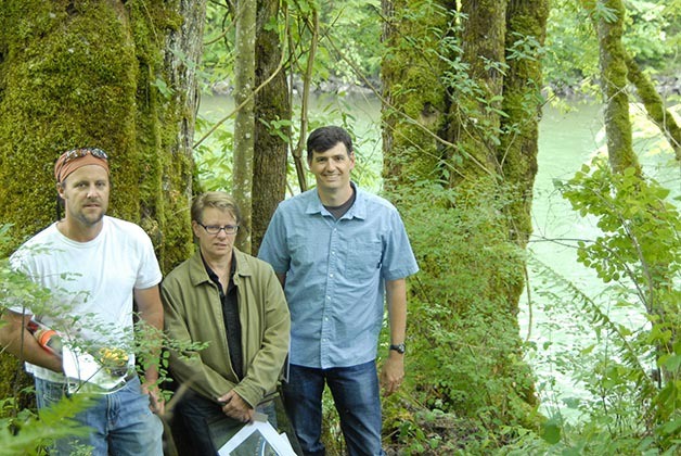
Geologist Todd Hurley, center, describes the history of the Upper Carlson project, with maps and photos held by ecologist Kollin Higgins, left, and Watershed Steward Mary Maier, right.
![]()
Along the river, trees are being uprooted, below, and used to anchor the new levee.
![]()
A second stop on the Watershed Forum’s tour was the former Tall Chiefs Golf Course, which King County bought last year to return to its Agricultural Production District. Presenters, from left, are John Taylor, Assistant Division Director, Water and Land Resources Division; Janne Kaje, Snoqualmie Watershed Coordinator; Rick Reinlasoder, Livestock Program Specialist; and Kathy Creahan, Agriculture and Forestry Program Manager.