City rejects flood map, again
Published 2:36 pm Thursday, October 2, 2008
NORTH BEND — North Bend officials are once again ready to
appeal the latest version of a federally funded Flood Insurance Rate
Map because they say it is incomplete.
The map, on which Valley insurance rates are based, was revised
from a more than 20-year-old version that was considered outdated. It covers
the cities of North Bend and Snoqualmie, along with surrounding
unincorporated areas.
Last summer, Snoqualmie, North Bend and King County received
the map and were given 90 days to appeal it, which all three agencies did.
The map was produced by the Federal Emergency Management
Agency (FEMA), which was formed to respond to and mitigate for national
disasters, including flooding, and is responsible for delegating flood
studies. After the appeal process ended in January, FEMA made changes and
re-released the map Aug. 4.
But North Bend and King County are appealing again.
According to city officials, the map did not answer their
questions from the first appeal.
“Most of the information is about as accurate as it’s going to get, but
it could be better,” said engineering consultant David Carlton. “The city is
trying to make it better, to try to reflect reality in North Bend.”
Carlton is helping King County with its appeal and said that the
county has the same concerns with the map.
He explained that while there were not many big differences between
the 1999 and 2000 map versions, some floodways and floodplain areas
have been changed or added.
One of the main problems the city has is that FEMA did not provide
the calculations it used to determine elevations and floodways. The
model includes a mathematical representation of the path water would take
in the event of a flood.
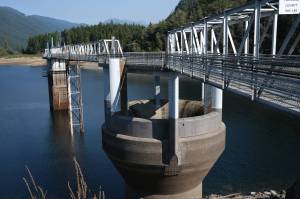
The map was developed from aerial photographs taken in 1995
and revised after the Army Corps of Engineers conducted a limited study,
using FEMA specifications, of the South and Middle forks of the
Snoqualmie River.
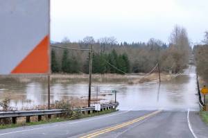
However, Ribary, Gardiner and Clough creeks were not included
in that study, which is another reason North Bend’s flood-management
staff is appealing the map.
Several homeowners that are hit by floodwaters from those creeks
agree with the city’s decision to appeal.
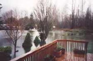
About eight North Bend residents attended the meeting last week
held by the city to discuss the appeal. Most were unhappy with the map, and
some said it has inaccurate elevations and falsely depicts which homes lie in
the floodplain.
“How can you put any emphasis on this new map if they’re not
using correct data?” asked Stephanie Huber, who has lived in the
flood-prone Shamrock Park neighborhood most of her life. Huber has tracked the
flood-mapping process and is the president of a non-profit organization,
South Fork Flood Relief Project, to find flooding solutions.
One concern residents have is that because the floodway or
floodplain distinction effects each homeowner, the map should be as accurate as
possible, not general.
“The (residents) feel they don’t have as much property rights as
other people,” said Clifford Cooper, engineer for the city of North Bend.
“The biggest thing that anybody would fear is suffering damage in a flood and
not be able to get repair done.”
Another main concern lies in where each home is placed on the
map, if it’s in a floodplain, meaning an area where water will gather, or a
floodway, which is the path or channel that water follows.
“If you can prove that you are not in the floodplain, you save
money,” Cooper added. “If you can show
by elevations that you were actually higher than FEMA thought you
were, the farther up you can prove you are above the water level, then you
don’t have to do as much flood-proofing.”
Cooper explained that since FEMA is federally funded, it has a
limited amount of money to complete as many studies as it can, which
means the Upper Valley map can’t be redone.
This means residents must pay for their own professional elevation
surveys to disprove FEMA’s calculations — a cost of approximately $130
per hour, Cooper said.
For this appeal period of 30 days, there was no time for residents to
arrange surveys.
The city of North Bend has until Sept. 4 to turn in its appeal, but
FEMA is not required to take the latest appeal into account or make
any changes, said Jeanette Mullin, mitigation specialist for FEMA and the
National Flood Insurance coordinator for the Upper Valley.
The possibility exists that another appeal period could be granted,
depending on the situation and the material the agency receives from
North Bend and King County, she added.
Meanwhile, the city of Snoqualmie will not be appealing
this map version as the changes they requested were made according
to Rhonda Montgomery, permit administrator for the city of Snoqualmie.
Regardless of city or county actions, Huber advises that Valley
residents get involved, find where their home is on the map and research
what happens if their property is damaged in a flood.
“People just don’t realize what could happen. They need to
educate themselves,” Huber said. “You
can’t wait until (a flood) happens. Everyone needs to realize the risk (of
flooding) and everyone needs to work on a solution.”
To review a copy of the map, visit Community Services at 126 E.
Fourth St. in North Bend.