It has been the most amazing winter. Little snow, below-average rains and above-average temperatures have made snow-free trips possible months before they normally would be.
It wouldn’t take too much to change things, as it is still winter. But as a follower of meteorologist Cliff Mass (cliffmass.blogspot.com), we are more than likely past any serious weather. There will still be some snow above 3,500 feet, but prognosticators are already signaling problems with the current 70-percent snow pack.
That said, here is an update on current trails. Close in, we have Mount Si, which at the moment is snow-free to the top. Further back along the ridge, you won’t have any trouble with a trip up Mount Tenerife, although you will find some snow.
During typical January trips, postholing is not uncommon if you forget your snowshoes. Not this year. Rattlesnake Ridge from the ledge to Snoqualmie Point is in good shape, except for being a little muddy in spots. Again, there is minimal snow where you should expect to see five feet or more this time of year.
Mount Washington does have spots of snow, but nothing that should be too challenging for the well-equipped. Snowshoes are still advisable, and you’ll pick up snow at about 3,500 feet and find some deep snow on the back side of the great wall. McClellan’s Butte, on the other hand, is still in winter mode, especially above 3,500 feet, and there is always danger in the multiple avalanche chutes. Traversing these chutes in the wrong kind of weather or after a snowfall can prove fatal if you do not know how to read the snow pack and see the danger signals. There is something about this peak that seems to attract people that have no business being on it during the winter months. They think they are hiking up Little Si, when they can end up with a serious alpine encounter. The top is dangerous in winter. Stay off it if you are not experienced.
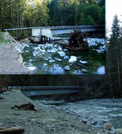
Good news is to be found out on the Middle Fork. If you actively hike the Middle Fork, you may already know that last January’s floods took out many sections of the road past mile point 5 and closures started as soon as the Mail Box Peak trailhead. Then, as work progressed, the barriers were lifted, and I, along with many others, took trips out as far as the campground where the blockade was due to the bridge washout. After the Labor Day weekend, things shut down again as work began in earnest to repair the Taylor River Bridge. The bridge replacement and road repair are part of the Federal Highways Emergency Flood Relief program. Funding for the road repair comes from the Western Federal Lands Highway Division of the Federal Highway Administration under the Emergency Relief to Federally Owned Roads Program.
All is now well, at least to the trailhead for Snoqualmie Lake, Taylor River, Lispsy Lake, and Otter Falls. Most of the 1988 structure was saved and the shore was brought out to the end of the bridge (a unique approach and well done from this non-engineering trekker — I never thought it would be repaired until this summer). The amount of work these folks from state, federal and private contractors accomplished is only appreciated if you had seen the devastation after the floods. When they finished, there was no fanfare, just the modest announcement that the road was now reopened. Well, I’m sure singing their praise to anyone who will listen!
Just be aware they face another huge task as they work to repair the road further up. Until further notice, all access up the valley to the Dingford Creek gate, including road access to Goldmyer Hotsprings, Dutch Miller Gap, and Hardscrabble Creek, is terminated. Let’s all hope this nice spring weather helps them complete this project. Next month, we’ll take a trip up a new trail here in the Valley. Have a hike you want to know more about? Shoot me a note and we’ll feature it in an upcoming column.
• When he’s not checking out new hiking web sites, Mark can be reached at marknich2@comcast.net.