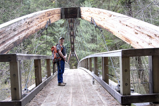
They call it the Gateway Trail. It’s a shortish trek, partly through old-growth forest, partly along the trout-rich Middle Fork of the Snoqualmie River, with a spectacular arching footbridge at its start. Hundreds of thousands of visitors come to the Middle Fork area each year for hiking, camping, kayaking, and cycling, and many will discover this spot. But, at 12 miles up a winding gravel road, is the Middle Fork Trail trailhead really a gateway?
In more ways than one, says Mark Boyar, now a Mountains to Sound Greenway board member, and one of the volunteers in the loosely organized Middle Fork Coalition who helped the U.S. Forest Service build that footbridge 12 years ago.
“This is the project that got a bunch of us started working out here,” explained Boyar, a recreation enthusiast who’s basically adopted the Snoqualmie corridor over the past 20 years. “It got a bunch of us excited, and we went from there.”
The project was a one-of-a-kind bridge, guarded day and night by volunteers during construction, and installed with the help of a two-rotor helicopter that lowered it, whole, into place. Interesting origins, yes, but the most important thing about the bridge, Boyar said, was the access it created.
“In the 80s and 90s, things had deteriorated so much, there was almost no formal trail system from this part of the Valley down,” he said, approaching the trailhead as he gave a tour of Greenway projects. “So we wanted to get more people up here for recreation purposes and the barrier was not having a bridge.”
Back then, Boyar explained, the Middle Fork, with more than 10,000 acres of convenient access and abandoned logging roads, was known to be the haunt of target shooters, garbage-dumpers and drug-users. It was U.S. Forest Service land, with state- and county-owned pieces, too, and most was reserved for outdoor recreation, but people didn’t feel safe here, so they didn’t come out here.
Over the last 10 to 20 years, though, everything changed. The U.S. Forest Service closed off many of the old logging roads, and banned shooting in the area. In 1995, the Mountains to Sound Greenway began a planning effort to address some of the major restoration needs, from building trails on decommissioned roads, to repairing river banks damaged by decades of users blazing their own trails down to the water, and then blocking vehicle access to some of the most sensitive areas. The U.S. Forest Service created a campground near Taylor River. Various agencies hired Friends of the Trail to clean up illegal dumpsites, and provide ongoing maintenance. Slowly, and then more quickly, recreational tourists started coming back to the Middle Fork
For Boyar, it was a mixed blessing—more tourists meant more interest in the area, more revenue for surrounding communities, but more chances for misuse of the resources such as “bootleg” trails and campsites. It was also a warmup for what he foresees in the next few years for the Middle Fork.
Right now, the Western Federal Lands Highway Division is planning a major road reconstruction and paving project for 10 miles of the Middle Fork Road, and the U.S. Congress is considering a bill that would add 22,000 acres to the Alpine Lakes Wilderness that covers part of the Middle Fork area. The bill, S. 112: Alpine Lakes Wilderness Additions and Pratt and Middle Fork Snoqualmie Rivers Protection Act, would also designate the Middle Fork as a wild and scenic river, qualifying it for additional protection and federal management.
![]()
Carol Ladwig/Staff Photo
The Middle Fork makes for pleasant camping, but with possible designation as a wild and scenic river, it may come under increased protection in the future.
Solving problems
Locally, the North Bend City Council just authorized the public works department to apply for a $6 million federal grant, with a $614,000 match (13.5 percent) from the city’s Transportation Benefit District funds, to prepare the city’s own gateway, 468th Avenue Southeast, for the additional traffic and construction vehicles coming soon to the Middle Fork Road. The project will include widening the roads, adding sidewalks, and constructing an oversized truck turnaround, casually referred to as a roundabout, at the intersection of 468th Southeast and Southeast 140th Street/Southeast Middle Fork Road.
“It solves an awful lot of problems out in that area,” said North Bend Public Works Director Frank Page of the project, which he hopes could start as soon as next spring.
Improving the overall access to the area, while simultaneously expanding the lands that will be accessible to hikers, et. al., won’t mean a rush of new users to the area, Boyar says, because they’re already here.
“I don’t think it’s going to be a flood, but I’d say the faucet will be three-quarters open,” Boyar said. “It’s going to be busy!”
And time is running out for advocates of the Middle Fork to plan and produce the amenities —more signs, day-use areas, campgrounds, outhouses, pullouts and trails, all in the right non-sensitive areas—that will accommodate and maybe even direct all those visitors.
“It’s not a choice of (them) coming or not coming, because they’re here and they’re coming in droves. It’s whether we want this place to be the same damn mess that we had 20 years ago,” Boyar said.
The Greenway, with funding from a Waste Management grant, has begun a planning process with the various land-management agencies in the Middle Fork to design what the next phase of the Middle Fork area, the accessible Middle Fork, will look like.
“Then, those people, who are coming anyway, will have a great time and they won’t inadvertently cause the disruption that you’re seeing right now,” says Boyar, stopped at a “bootleg” campsite, maybe 30 feet from the road. Campers cut their own trail to a clearing on the riverside, then apparently took a chainsaw and can of spray paint to a live tree, cutting out a four-foot section of bark and wood, probably for their fire.
![]()
Carol Ladwig/Staff Photo
Mark Boyar, a Mountains to Sound member and advocate of the Middle Fork planning effort, gave a tour of restoration projects, including repairing damage caused by bootleg campsites like this one.
The right way
“We can either do this road project right, so that we can get in the way of that process of degradation, so we can prepare the valley in the right way and focus the use,” Boyar said, or let it become like some of the other river basins he’s heard horror stories from. “So this is the opportunity to fix it before the problem happens. It’s the Yosemite taking care of the crowds before the crowds come.”
While at the bridge, a man passed Boyar, heading out on the trail with a small chainsaw in hand, and a hatchet strapped to his daypack. He could have been one of the many volunteers with Mountains to Sound, helping to keep a trail clear after getting a report of a problem somewhere—they have a similar program for weeds that Boyar is very excited about. Or, he could have been a bootlegger, about to cut his own trail into the shared treasure of the Middle Fork. With all this access, you just can’t tell.
Learn more about the Middle Fork road project at www.wfl.fhwa.dot.gov/projects/wa/snoqualmie/purpose_and_need.htm.